How the GeoGotar Platform Works
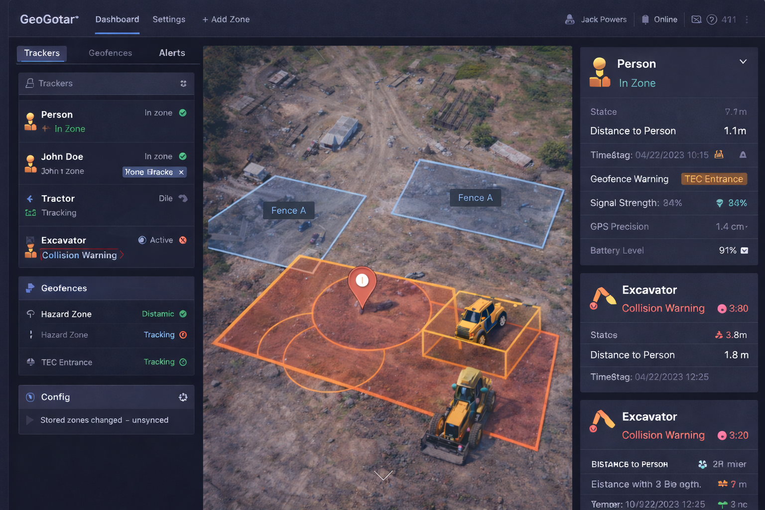
GeoGotar Platform is the operational control layer behind the GeoGotar ecosystem. It provides a web-based interface where teams can manage GPS, RTK-enabled trackers, view asset and worker positions, create geofences, and configure how devices should respond when field events occur.
From a single dashboard, users can onboard and configure trackers, organize them by site or project, assign each device to a specific machine or worker, and define which zones and rules should be loaded onto that device.
The platform supports both static geofence zones and dynamic zones. Static zones are used for restricted areas, hazard boundaries, work zones, no-entry regions, storage areas, and other fixed location rules. Dynamic zones move together with a worker, vehicle, or piece of equipment and help detect proximity and collision risks in real time.
What Users Can Do in the Platform
- Create, edit, and delete static geofence zones on the map.
- Configure dynamic zones that move with equipment or personnel.
- Assign trackers to tractors, excavators, rollers, workers, or other assets.
- Select which geofences and rules are loaded onto each device.
- View whether a zone is active locally on the device or only in the cloud.
- Monitor battery level, signal strength, GPS precision, and device health.
- Review collision warnings, zone-entry events, and other safety alerts.
- Update device behavior, alert logic, and operational settings remotely.
Tracker and Device Configuration
Each tracker in the GeoGotar Platform can be configured with a role, asset identity, and field behavior profile. For example, a tracker can be assigned to a worker, an excavator, a tractor, or a compactor, and the platform can apply a different set of geofences, proximity rules, and alert thresholds depending on that role.
Users can also inspect whether the latest geofence configuration has been synchronized to a device, which zones are currently loaded locally, and which alert rules are active on that tracker. This is especially important for environments where offline-capable device logic is required.
Map-Based Geofence Management
The platform provides a visual map interface for creating and managing zones directly on top of the operating environment. Teams can draw polygons for fixed areas, define radius-based safety buffers, and visualize dynamic zone overlap between workers, vehicles, and equipment.
Each zone can include metadata such as type, severity, assigned site, active schedule, target asset classes, and response behavior. This makes the platform useful not only for real-time alerting, but also for compliance, workflow control, and operational planning.
Visibility Into Device and Zone Status
GeoGotar Platform does more than show position on a map. It provides operational visibility into what the device is actually doing. Supervisors can see whether a tracker is online, when it last reported, what its current precision level is, what battery state it is in, and whether the correct zones and logic are currently deployed.
This makes it easier to diagnose field issues, validate configuration changes, and confirm that the right safety logic is active before teams begin work.
Key Benefits of the GeoGotar Platform
- Manage trackers, zones, and alert logic from one platform.
- Support both cloud-managed and on-device geofence workflows.
- Assign devices and safety rules to workers, vehicles, and equipment.
- Visualize which zones are static and which are dynamically moving.
- Monitor telemetry, synchronization state, and device health in real time.
- Reduce configuration errors across large or changing job sites.
- Scale from a small pilot deployment to a multi-site operation.